
High-Precision GNSS Solutions: A 2026 Technical and Application Primer
High-precision GNSS has become standard infrastructure for machines that must steer, map, and navigate with controlled accuracy. In 2026, buyers considering high-precision GNSS solutions for UAVs, precision agriculture, autonomous vehicles, fleet management, robotics, or surveying will evaluate not just accuracy claims but the complete chain: receiver, antenna, differential correction, and integration support. This article provides a technical review of high-precision GNSS solution categories, how the positioning chain works, and which selection factors matter in industrial purchasing decisions.

JUMPSTAR CO., LIMITED is headquartered in Shenzhen, a central node of the global GNSS hardware supply chain.
Why centimeter-level positioning is now an industrial requirement
Standard GNSS modules commonly achieve horizontal accuracy of roughly 1 to 2.5 meters. That is sufficient for vehicle navigation and general asset tracking, but not for automation tasks. Surveying UAVs need repeatable flight trajectories; agricultural machines must keep row-level path consistency; autonomous vehicles require lane-level integrity; and mobile robots need to operate against fixed industrial infrastructure. In these cases, positioning shifts from a convenience feature to a control input.
The industrial demand is visible in market data. The global high-precision GNSS market was valued at USD 7.8 billion in 2024 and is projected to reach USD 20.6 billion by 2033, according to Dataintelo. The high-precision GNSS module segment was estimated at USD 1.5 billion in 2024 and is forecast to reach USD 4.5 billion by 2035, based on Market Research Future data. On the application side, agriculture is currently the dominant segment for high-precision GNSS, holding a 36.8% market share in 2025 according to the High-Precision GNSS Market Research Report 2034.
The building blocks of high-precision GNSS solutions
High-precision GNSS solutions span several distinct product tiers. For an industrial buyer, understanding this structure is a practical starting point:
- RTK GNSS modules — compact board-level modules designed to be embedded into UAVs, robots, vehicle electronics, and handheld terminals. Examples include the JS-ANK45-2 with 1408 super channels and RTK horizontal accuracy of 1.5 cm + 1 ppm, and the JS-RK26-3 dual-band L1/L5 module with 200 tracking channels.
- High-precision GNSS receivers — board-level or boxed receivers with richer interface options, such as dual UART, USB, 4G, CAN, TF-card logging, and external antenna ports. The G27SH-AH receiver supports GPS, BDS, GLONASS, Galileo, QZSS, NavIC, and SBAS with 789 hardware channels and RTK horizontal accuracy of 0.6 cm + 0.5 ppm.
- Smart antennas — integrated receiver-plus-antenna assemblies that simplify mechanical and RF design. The JS-SK43H-AH, for example, provides multi-band RTK positioning and dual-antenna heading in a 48.0 × 43.2 × 37.0 mm package weighing less than 24 g.
- GNSS antennas — passive or active antennas matched to positioning engines. Product families include helical antennas for UAVs, vehicle-mounted antennas with magnetic bases, and dual-band ceramic antennas with IPX7 protection.
- GNSS + INS modules — receivers that integrate inertial measurement units to maintain positioning when satellite signals are temporarily blocked. The JS-RK26-U, for instance, combines dual-band L1/L5 GNSS with an IMU and weighs less than 1.1 g.
JUMPSTAR CO., LIMITED, established in 2013 and based in Shenzhen, China, is an example of a source manufacturer serving this multi-tier structure. The company operates a 5,000-square-meter manufacturing facility with a development team of 20 engineers and an annual production capacity of 100,000 units. Its product scope covers RTK modules, GPS antennas, GNSS receivers, GNSS modules, UAV GPS modules, and anti-jamming GPS antennas. Export sales account for about 70% of total revenue, with primary markets in the European Union, the United States, and the Middle East.
How centimeter-level accuracy is achieved
Centimeter-level positioning in production systems comes from a combination of receiver capability and differential correction. A multi-constellation, multi-frequency front end tracks signals from GPS, BeiDou, GLONASS, Galileo, QZSS, NavIC, and SBAS. The receiver applies correction data from a base station - either a local base or a network service such as NTRIP/CORS - to compute an RTK fixed solution.
Specific hardware choices determine what the system can deliver. The G27SH-AH receiver provides RTK horizontal accuracy of 0.6 cm + 0.5 ppm, 1PPS timing accuracy of 1.4 ns, signal latency of 99.9% below 10 ms, and IP67-rated protection. The JS-ANK45-2 module offers 1408 super channels, RTK initialization of less than 5 seconds, and a 20 Hz update rate. At the high-accuracy end, the JS-SK40 module achieves RTK horizontal accuracy of 0.6 cm + 0.5 ppm and vertical accuracy of 1 cm + 1 ppm under 24-hour static conditions with at least 15 satellites.
Several supporting technologies are equally important in industrial deployments:
- Inertial coupling. Modules such as the JS-RK26-U and S-C8A fuse GNSS with IMU data. The JS-RK26-U keeps positioning error within 5% of travel distance after 120 seconds of GNSS signal loss, which is valuable in tunnels, dense urban areas, and container yards.
- Anti-jamming and anti-spoofing. The JS-X168 is a five-element anti-jamming GNSS receiver with 115 dB suppression for a single interferer and 95 dB for three simultaneous interferers. Receivers such as the P-Box-X6_Pro S and P-Box-AP55 add Galileo OSNMA anti-deception support and interference monitoring.
- Dual-antenna heading. Dual-antenna configurations provide real-time heading, pitch, and roll. The JS-SK43H-AH and P-Box-X6_Pro S deliver heading accuracy of 0.15° at a 1 m baseline and 0.03° at a 5 m baseline, which supports lane-keeping and accurate trajectory reproduction.
- High dynamic range. UAV and vehicle deployments may face acceleration up to 4 g and speeds up to 515 m/s. Components such as the JS-HAC18A-F helical antenna, rated for IP65 and weighing 10.8 g, are built for such environments.
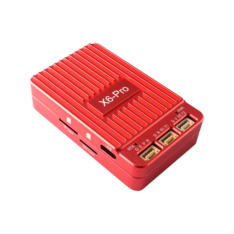
The P-Box-X6_Pro S is an industrial-grade GNSS RTK receiver combining 4G RTCM connectivity, anti-jamming, and optional dual-antenna heading output.
Deployment scenes: UAV mapping, agriculture, vehicles, fleets, and robotics
The practical value of high-precision GNSS is best understood through deployment scenarios, each with distinct hardware requirements.
| Application | Key requirements | Representative product types |
|---|---|---|
| UAV surveying and mapping | Centimeter-level RTK, heading output, light antenna, high update rate | G27SH-AH, JS-CK43-2, JS-SK43H-AH, JS-HAC18A-F |
| Precision agriculture | RTK smart antennas, auto-steering support, wide temperature range | JS-MK43, JS-ANK45-2 |
| Autonomous vehicles / assisted driving | Dual-antenna heading, anti-jamming, multi-band RTK | P-Box-X6_Pro S, P-Box-AP55, JS-SK43H-AH |
| Fleet management | 4G RTCM connectivity, wide input voltage, vibration resistance, durable antennas | P-Box-X6_Pro S, JS-HAS67A-D2, JS-PAS51A-D5 |
| Robotics and UGVs | Small form factor, low power, GNSS+INS coupling | JS-RK26-U, S-C8A, JS-AP08-PR |
In UAV aerial surveying, the vehicle must carry a positioning payload that supports high-dynamic flight while maintaining RTK lock. Documented operating conditions for such systems include acceleration up to 4 g and speeds up to 515 m/s. The JS-CK43-2 smart antenna, designed for UAV high-precision navigation, provides RTK horizontal accuracy of 0.8 cm + 1 ppm and can output positioning/RTK data at 50 Hz. The JS-HAC18A-F antenna, at 18 mm in diameter and 10.8 g in weight, gives light UAVs a low-mass, IP65-protected precision antenna option.
In fleet management, the device is fixed inside vehicles such as logistics trucks, construction machinery, agricultural machines, and inspection vehicles. Operating temperature ranges from -40°C to +85°C, with storage from -55°C to +85°C; the receiver must tolerate sustained high-frequency vibration from the engine and road surface. The P-Box-X6_Pro S responds to this requirement with a 4.5–12.0 V DC input range, a full-band 4G module for NTRIP correction, TF-card raw data logging, anti-jamming, and optional dual-antenna heading output. Fleet application scenarios are documented in China, Japan, and Singapore.
Market signals and the source-manufacturing shift
The high-precision GNSS market is expanding across both the system and module layers. The GNSS downstream market as a whole is forecast to reach EUR 580 billion in revenue by 2034, according to EUSPA. In the high-precision segment, agriculture is the leading application at 36.8% of the market in 2025, while the precision farming market itself is projected to grow from USD 11.38 billion in 2025 to USD 21.45 billion by 2032, based on MarketsandMarkets data.
Established measurement brands continue to shape the market. The mid- and high-level precision GPS receiver segment is led by Trimble, Hexagon AB, Topcon, and Hemisphere GNSS, according to Mordor Intelligence. Trimble launched the R12i GNSS system in 2024 with integrated IMU technology for enhanced RTK performance, indicating that inertial coupling is now a mainstream expectation rather than a niche feature.
Source manufacturers from China are adding a different layer to the procurement landscape. By offering modules, receivers, smart antennas, and antennas from a single production site, they allow integrators to consolidate specifications, quality control, and volume supply under one engineering relationship. It is a model that shifts purchasing emphasis from a single finished-goods box toward a longer-term system-level partnership.
Limitations and trade-offs buyers should weigh
High-precision GNSS is not a universal substitute for simpler positioning. Several constraints should be considered before committing to an RTK-based architecture.
- Differential correction dependency. RTK requires a correction data stream from a local base station or an NTRIP/CORS network. Sites without reliable cellular coverage may need to deploy their own base station. The JS-X11, for example, is an all-in-one RTK base station with 9–45 V DC input, IP66 protection, and support for 4G Cat.1 and BLE 5.2, which can serve as a local correction source.
- Environment sensitivity. Urban canyons, dense foliage, and strong electromagnetic interference can degrade signal quality. Multi-constellation, multi-frequency tracking, anti-jamming, and multipath mitigation improve resilience but increase hardware cost. Buyers should assess whether the operating environment justifies those features.
- Cost and power. RTK modules and receivers consume more power and cost more than standard modules. For non-automated asset tracking and simple logistics monitoring, a standard accuracy module may be the more rational choice. The JS-ATP28-2, a single-frequency multi-constellation module with a 28.0 × 28.0 × 7.0 mm footprint, illustrates this category.
- Integration effort. Antenna placement, cable routing, 4G connectivity, and firmware configuration are part of the engineering work. A turnkey receiver reduces some risk, but system-level testing remains essential.
What comes next: broader integration, deeper autonomy
The direction of the market is toward tighter integration and lower cost per centimeter. As the high-precision GNSS module market grows from USD 1.5 billion in 2024 to an expected USD 4.5 billion by 2035, a wider range of devices - from light UAVs to autonomous shuttles and agricultural robots - will gain access to RTK-level accuracy.
Galileo High Accuracy Service, which delivers horizontal accuracy down to 20 cm, provides another path for applications that need sub-meter performance without full RTK infrastructure. ISO 12188 parts 1 and 2, which define test procedures for positioning and guidance systems in agriculture and forestry, also indicate a broader institutional interest in making precision claims verifiable.
For industrial buyers, the practical consequence is that high-precision GNSS is becoming less of a differentiator and more of an assumed requirement. The future belongs to suppliers who can combine receiver performance, antenna quality, production capacity, and long-term engineering support in a consistent way.
Reference for buyers: For the full JUMPSTAR product catalog - including RTK modules, GNSS receivers, smart antennas, GNSS antennas, and manufacturing details - see the official company profile: JUMPSTAR Company Profile 2026.
FAQ
What are high-precision GNSS solutions?
High-precision GNSS solutions are positioning systems that provide centimeter-level accuracy using multi-constellation, multi-frequency receivers and differential correction methods such as RTK. They include RTK GNSS modules, high-precision GNSS receivers, smart antennas, GNSS antennas, and GNSS+INS modules, often paired with base stations or network correction services.
Why do high-precision GNSS solutions need multi-band, multi-constellation support?
Multi-band and multi-constellation support increases the number of visible satellites and the robustness of signal tracking in difficult environments. Products such as the G27SH-AH with 789 hardware channels track GPS, BDS, GLONASS, Galileo, QZSS, NavIC, and SBAS, reducing the impact of blocked signals and multipath in urban canyons or under foliage and helping the receiver maintain a stable RTK fixed solution.
How is high-precision GNSS used in UAV systems?
Surveying UAVs use RTK receivers and smart antennas for centimeter-level positioning, with heading output for accurate trajectory reproduction and image overlap. Components such as the JS-HAC18A-F helical antenna (18 mm diameter, 10.8 g, IP65) support light UAV integration, while high-dynamic products such as the JS-CK43-2 handle acceleration up to 4 g and speeds up to 515 m/s.
Which GNSS products are common in precision agriculture?
Precision agriculture commonly uses RTK smart antennas and high-precision modules for auto-steering and implement control. The JS-MK43, intended for agricultural automation and precision farming, provides RTK accuracy of 2 cm + 1 ppm horizontal, operates from -40°C to +85°C, and supports protocols including NMEA 0183 and RTCM 3.X. Agriculture is the largest application segment of the high-precision GNSS market, holding a 36.8% share in 2025.
What should fleet operators evaluate when selecting a high-precision GNSS receiver?
Fleet operators should check wide-voltage power input (for example 4.5–12 V DC), operating and storage temperature ranges, 4G or cellular connectivity for NTRIP correction, raw-data logging, anti-jamming capability, and optional dual-antenna heading output. The P-Box-X6_Pro S is an example of a receiver that integrates these capabilities for vehicle-mounted deployment.
When is RTK not necessary in a GNSS solution?
RTK is not necessary when the application tolerates meter-level accuracy. Standard GNSS modules are sufficient for general logistics tracking, simple vehicle monitoring, and many portable positioning tasks. For example, the JS-ATP28-2 achieves a vertical positioning accuracy of 3.75 m (CEP 50%) in open-sky conditions with a compact single-frequency footprint, making it a lower-cost alternative for non-automation applications.
Tem questões ou precisa de mais detalhes?
Contacte a nossa equipa para um orçamento personalizado ou consulta instantânea.
Solicitar orçamento
Preencha o formulário abaixo e a nossa equipa entrará em contacto com uma proposta personalizada.
Chat direto do WhatsApp
Prefere conversar em tempo real? Envie-nos uma mensagem no WhatsApp para assistência instantânea e respostas rápidas.
- Obter orçamento personalizado
- Partilhar fotos ou documentos
- Discuta as suas necessidades diretamente
Geralmente responde em 5–30 minutos durante o horário de expediente.